
 |
| MAGIC’s GIS Data Page has new Data Categories |
MAGIC’s GIS Data Webpage was recently given a makeover! Data is now organized in the following categories:
- Boundaries
- Census
- Education
- Election
- GeoScience/Environmental
- Hydrography
- Indexes
- Places
- Roads & Transportation
 |
| The downloadable GIS data on MAGIC’s page has been reorganized for better usability. |
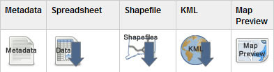
In addition, the downloadable data has changed. You will find Metadata, Spreadsheet data, Shapefiles, KML’s and a Map Preview option which allows you to preview data in Google Maps. Shapefiles are now conveniently compressed; .zip files now include statewide (or applicable geography-wide) data. Three different shapefiles are included in each compressed file; each with a different coordinate system (Connecticut NAD83 feet, NAD83 meters and WGS84, respectively).