
 |
| On the left, UConn (Storrs Campus) in 1934; on the right UConn (Storrs Campus) present-day. |
A recent blog post highlighted the new GIS Data Distribution Page on MAGIC’s website. In addition to the new look on this page, the Aerial Photography Page has been updated as well! Now, when you visit this page, you will find aerial photography of Connecticut from the following sources:
- Connecticut Ecological Conditions Online (CT ECO) Aerial Photography Viewer
- Connecticut Historical Aerial Imagery from MAGIC
- Connecticut Historical Aerial Photography from the Connecticut State Library
- Connecticut Historical Aerial Photography Mosaic Map Mash-Ups from MAGIC
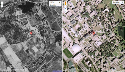 |
| A Screenshot from MAGIC’s CT Aerial Photography Mosaics Mash-Ups. The red marker indicates our location, Homer Babbidge Library. On the left, imagery from 1934, and to the right, Google’s current imagery. |
The Connecticut Aerial Photography Mosaic Mash-Ups enable you to view, pan and zoom linked historical (1934, 1991, 2006, or 2008) and and contemporary imagery…check it out!