
This is the fifth in a series of posts featuring web-based maps developed by the University of Connecticut Libraries Map and Geographic Information Center (MAGIC) for the On The Line project.
Suburbanization is a spatial phenomenon that has influenced the way in which we live in the United States. Throughout the 20th century, wealth decentralized. At the beginning of the century, the majority of wealth was concentrated in the central city and, as the century progressed, it migrated to the suburbs. Much of this occurred following World War II and the development of the interstate highway system, which made middle-class workers more mobile and proliferated commuting by automobile. A consequence of this migration pattern is that the central city is often left with a lower tax base per capita, and thus, fewer resources to provide services.
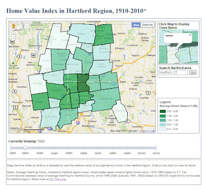 |
| Click to visit the Home Value Index in Hartford Region (1910-2010) time-slider map. |
As a part of our collaboration with On The Line, MAGIC produced a dynamic time-slider map of home values that shows this migration of wealth in the Hartford metropolitan area. To correct for inflation, we indexed each town’s average home value to the regional average for each decade (labeled as 1.00). Darker green areas represent home values higher than the regional average. This map brings together nearly a century of town-level data from two sources: assessed dwelling values that have been equalized for comparison (from the Connecticut Tax Commissioner reports, 1910-1980) and market sales transactions of single-family homes (from the Capitol Region Council of Governments, 1990s-2000s).
Note: We are still working on obtaining comparable home value data for 2010.
The wealth migration map above is similar to the racial change time-slider map that was featured in an earlier blog post, but differs in how the towns are symbolized. In the map of racial change, each town is symbolized based on the percentages in each town. In the map home value index change, each town is symbolized by how its average home value compares to the average for the region as a whole.
With support from the National Endowment for the Humanities, MAGIC created this and other interactive maps with Jack Dougherty of Trinity College for the On The Line project. This and other maps are freely accessible in a public history web-book, entitled On The Line: How Schooling, Housing and Civil Rights Shaped Hartford and its Suburbs. On The Line tells the story of schooling and housing boundary lines that divided metropolitan Hartford, Connecticut over the past century, as well as the struggles of ordinary families and civil rights activists who sought to cross over, redraw or erase these lines.
Technical Detail:
The cartographic layers for the Home Index in Hartford Region animated time slider map were created using ESRI’s ArcMap software, then exported as KMZ files using the ArcToolbox conversion tool.
This interactive map utilizes the Google Maps API v3 in addition to JavaScript code developed by Thomas Bachant and Jean-Pierre Haeberly to create the interface that incorporates each KMZ file by year with a time slider. Each time the time slider is moved, the corresponding KMZ file for that year is asdded to the map to allow users to visualize the data.
Special Thanks to Thomas Bachant and Jean-Pierre Haeberly for developing the custom JavaScript for this map!