2016 Connecticut Aerial Photography Now Available via CTECO

Our colleagues at the Center for Land Use Education and Research (CLEAR) have just announced the statewide, 2016, 3 inch aerial imagery is now available via the CT ECO Website! This imagery is available for use in a wide range of ways depending on the users need/application. Included below is an overview of the options available for viewing and downloading the 2016 Connecticut aerial photography:

  • as a dynamic image service and a cached image service
  • for download by tile (PLEASE use the download manager if you will be downloading more than a couple of tiles) and
  • in the Aerial Imagery Viewer for viewing
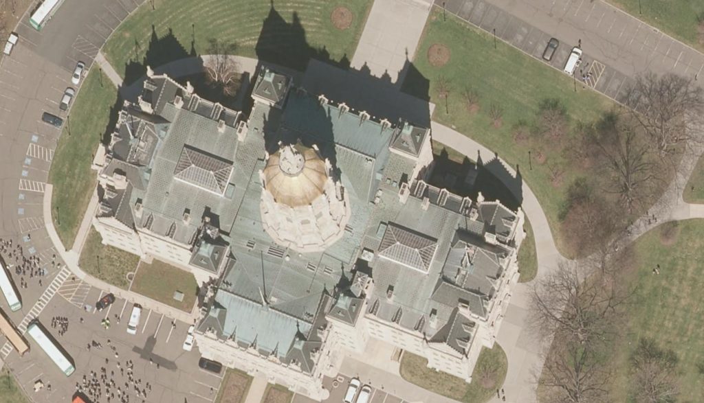
2016 Aerial Photo Sample

Stay tuned for more options as town mosaics for download an all lidar products including DEM tiles, elevation image services and LAS files are made available from CT ECO and CLEAR.

The project was managed by the Capitol Region Council of Governments (CRCOG), on behalf of the Connecticut regional councils of governments, and funded by the Connecticut Office of Policy and Management (OPM) with contributions from the Connecticut Department of Transportation (DOT) and the Connecticut Department of Emergency Services and Public Protection (DESPP).  The project management team includes municipal, regional, state and university representatives. 


“Lost” New England landscape found using LiDAR

magic_all

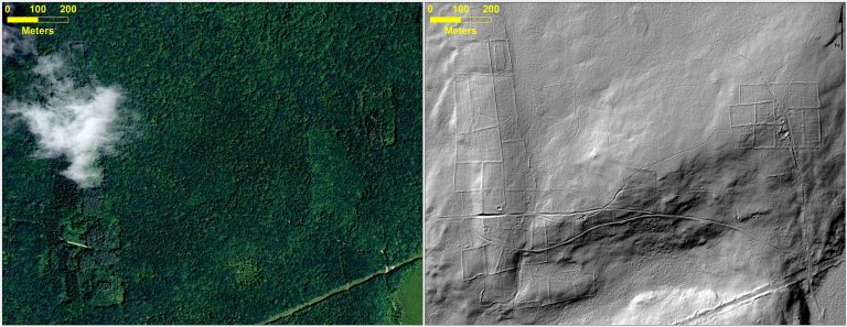
At top left, leaf-on 2012 aerial imagery from Connecticut (CTECO); top right is 2010 hillshaded DEM derived from LiDAR data showing stone walls, old road and building foundation; bottom is 1934 aerial photography (available from MAGIC and CT State Library)


New research by Geography graduate student Katharine Johnson and faculty William Ouimet was covered yesterday by National Geographic in their article “Lost” New England Revealed by High-Tech Archaeology. The article features a Q & A with Katharine Johnson, a PhD student in Geography and employee here at MAGIC and the Connecticut State Data Center.

You can read it (and see some cool graphics) here: http://news.nationalgeographic.com/news/2014/01/140103-new-england-archaeology-lidar-science

The article references a paper by Johnson and Ouimet that was recently accepted and published by the Journal of Archaeological Science about using Light Detection and Ranging (LiDAR) to identify and analyze the historic agricultural landscape of New England that is now hidden by the forest canopy in aerial photography but is visible using LiDAR. Check it out, here:  http://www.sciencedirect.com/science/article/pii/S0305440313004342

Coastal imagery for Connecticut

Recently, imagery available at the Map and Geographic Information Center (MAGIC) here at UConn has been used to map and understand shoreline change in Connecticut. Many different series of historical aerial photographs are available on the MAGIC website, in addition to infrared coastal photography which allows for an easier visual comparison between water and land. View our various indexes here: http://magic.lib.uconn.edu/mash_up/aerial_index.html and an introduction to the imagery by Michael Howser here.

Aerial1934

1934 aerial photograph – Bluff Point State Park, Groton

Aerial1996

1995 aerial photograph – Bluff Point State Park, Groton


Back in May, WFSB, a local news station, ran a story on Joel Stocker at UConn’s CLEAR (Center for Land Use Education and Research). Stocker & CLEAR are using some of MAGIC’s imagery as well as historic maps to look at shoreline change in Connecticut from as recently as hurricane Sandy all the way back to the 1800s.

Last week, “A MAGICal look at the shore,” an article written by Suzanne Zack in Wrack Lines, the official magazine of the Connecticut Sea Grant program, discussed how using MAGIC’s imagery can inform planning and management decisions by tracking changes in the past.

Another excellent resource in looking at coastline change is NOAA’s Digital Coast, which offers free LiDAR (Light Detection and Ranging) data that can be downloaded and processed. Pre- and post-Sandy LiDAR datasets are available in LAZ format, the zipped standard for LAS files. LAZ files can be unzipped using LASzip. The LASzip website also allows you to batch download LiDAR files available via Digital Coast, as well as other states like Alaska, Minnesota, Virginia, and others. If you’re interested, here are some basics about LiDAR from ESRI.

DigCoast

2012 Connecticut statewide 4-band aerial imagery

The 2012 statewide aerial imagery is now available!

http://www.cteco.uconn.edu/help/info_orthos2012.htm

Some of the basic facts:

  • 4 bands (R,G,B,NIR)
  • 1 foot pixel resolution
  • Flown in March 2012 (leaf-off)
  • Each tile covers 2.3 square kilometers (0.897 sq mi) and is 97.696 MB

It was paid for through a partnership between Connecticut Department of Emergency Services and Public Protection (DESPP), the Connecticut Department of Transportation (DOT), and the National Geospatial Intelligence Agency (NGA) along with the United States Geological Survey (USGS) providing support through project management, contracting and quality assurance/quality control (QA/QC).

The download interface allows you to download a mosaic for a whole town in JP2 format, or as individual GeoTiffs or MrSIDs. Users can also access the layer remotely through CTECO’s Map Services.download_interface

Examples:

2012_ashforest

Forested area in Ashford, Bands 1, 2, 3

2012_ashforestIR

Forested area in Ashford – Bands 4, 2, 1

2012_hartford

Downtown Hartford, Bands 1, 2, 3

2012_hartfordIR

Downtown Hartford, Bands 4, 2, 3

CT ECO News and Updates

Connecticut Ecological Conditions Online (CT ECO) has recently updated their data and image services and offerings! Included below is an update from CT ECO as of August 3, 2011, which includes new links to aerial photography image services for ArcGIS Users:

  • Updated Data: Aquifer Protection Area information was updated in the Map Catalog, Simple Map Viewer, Advanced Map Viewer, and for GIS and AutoCAD users, the Water Resource Management map service.
  • Updated Data: Natural Diversity Data Base Area information was updated in the Map Catalog, Simple Map Viewer, Advanced Map Viewer, and for GIS desktop software users, the Habitat map service. The date of the new information is July 2011.
  • Updated Data: Surface Water Quality Classification information was updated in the Map Catalog, Simple Map Viewer, Advanced Map Viewer, and for ArcGIS Desktop software and AutoCAD users, the Water Resource Management map service.
  • New Viewer: CT ECO Aerial Photo Viewer is for viewing and printing statewide and regional orthophotography available for Connecticut.
    Select to open the Aerial Photo Viewer
  • For Map Service users, URLs to othophotography image services have been changed to a different server (ctecoapp3).
    1. Use http://www.ctecoapp3.uconn.edu/arcgis/services to connect to othophotography.
      Image Service NEW ArcGIS Server Image Service URL
      Ortho 1990 http://www.ctecoapp3.uconn.edu/arcgis/services/images/ortho_1990
      Ortho 2004 http://www.ctecoapp3.uconn.edu/arcgis/services/images/ortho_2004
      Ortho 2006 NAIP Color http://www.ctecoapp3.uconn.edu/arcgis/services/images/ortho_2006_Color_NAIP
      Ortho 2008 NAIP 4Band http://www.ctecoapp3.uconn.edu/arcgis/services/images/ortho_2008_4Band_NAIP
      Ortho 2010 NAIP 4Band http://www.ctecoapp3.uconn.edu/arcgis/services/images/ortho_2010_4Band_NAIP
      Ortho 2008 Urban Area Color http://www.ctecoapp3.uconn.edu/arcgis/services/images/ortho_2008_color_urban_area
      Ortho 2009 Color CRCOG http://www.ctecoapp3.uconn.edu/arcgis/services/images/ortho_2009_Color_CRCOG
      Ortho 2004 Coast Color http://www.ctecoapp3.uconn.edu/arcgis/services/images/ortho_2004_Coast_Color
      Ortho 2004 Coast Infrared http://www.ctecoapp3.uconn.edu/arcgis/services/images/ortho_2004_Coast_Infrared
    2. The following image services are in the process of being re-created in ArcGIS 10 and is currently not available. They will be made available as soon as possible. We apologize for any inconvenience this may cause.
      Image Service NEW ArcGIS Server Image Service URL
      Ortho 2005 Coast Infrared http://www.ctecoapp3.uconn.edu/arcgis/services/images/ortho_2005_Coast_Infrared
      Ortho 2010 Coast Infrared http://www.ctecoapp3.uconn.edu/arcgis/services/images/ortho_2010_Coast_4Band
  • Aerial Photography of Connecticut

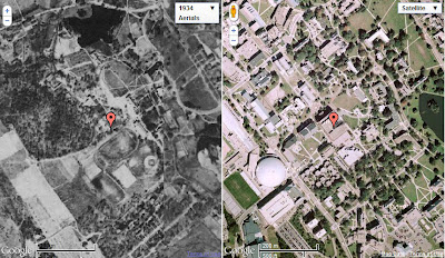
    On the left, UConn (Storrs Campus) in 1934; on the right UConn (Storrs Campus) present-day.

    A recent blog post highlighted the new GIS Data Distribution Page on MAGIC’s website. In addition to the new look on this page, the Aerial Photography Page has been updated as well! Now, when you visit this page, you will find aerial photography of Connecticut from the following sources:

    • Connecticut Ecological Conditions Online (CT ECO) Aerial Photography Viewer
    • Connecticut Historical Aerial Imagery from MAGIC
    • Connecticut Historical Aerial Photography from the Connecticut State Library
    • Connecticut Historical Aerial Photography Mosaic Map Mash-Ups from MAGIC
    A Screenshot from MAGIC’s CT Aerial Photography Mosaics Mash-Ups. The red marker indicates our location, Homer Babbidge Library. On the left, imagery from 1934, and to the right, Google’s current imagery.
    The Connecticut Aerial Photography Mosaic Mash-Ups enable you to view, pan and zoom linked historical (1934, 1991, 2006, or 2008) and and contemporary imagery…check it out!

    MAGIC’s GIS Data Distribution Page Has New Look

    MAGIC’s GIS Data Page has new Data Categories

    MAGIC’s GIS Data Webpage was recently given a makeover! Data is now organized in the following categories:

    The downloadable GIS data on MAGIC’s page has been reorganized for better usability.
    In addition, the downloadable data has changed. You will find Metadata, Spreadsheet data, Shapefiles, KML’s and a Map Preview option which allows you to preview data in Google Maps. Shapefiles are now conveniently compressed; .zip files now include statewide (or applicable geography-wide) data. Three different shapefiles are included in each compressed file; each with a different coordinate system (Connecticut NAD83 feet, NAD83 meters and WGS84, respectively). 

    2010 Color and Infrared Imagery Now Available!

    The Connecticut Ecological Conditions Online (CT ECO) website has just added 2010 color and color infrared orthophotography for Connecticut to their online map viewer and map services. Included below are the details:

    • 2010 color and color infrared orthophotography for Connecticut from the National Agricultural Imagery Program (NAIP) – leaf on, 12 inch pixel resolution.
    • 2009 color orthophotography for 30 towns in the Capitol Region Council of Governments (CRCOG) area – leaf off, 3 inch pixel resolution.
    To view this new imagery, along with high-quality imagery for 1990, 2004, 2006, 2008 and more visit: http://cteco.uconn.edu/advanced_viewer.htm
    If you use ArcGIS and other GIS programs, you can add this imagery directly by using the CT ECO map services.

    Did You Know? #26

    You can view Aerial Photos directly from our photo indices!
    Use MAGIC‘s Google Map indices mash-up to search for aerial photos anywhere in Connecticut.

    Your browser does not support iframes.

    Years of aerial photos that are available for direct preview are:

    Other photo indices are available to preview in Google maps and will soon be enabled for direct photo preview. Also, as an alternative, download Google Earth and preview the indices in conjunction with other KML files from MAGIC’s GIS Data offerings.