
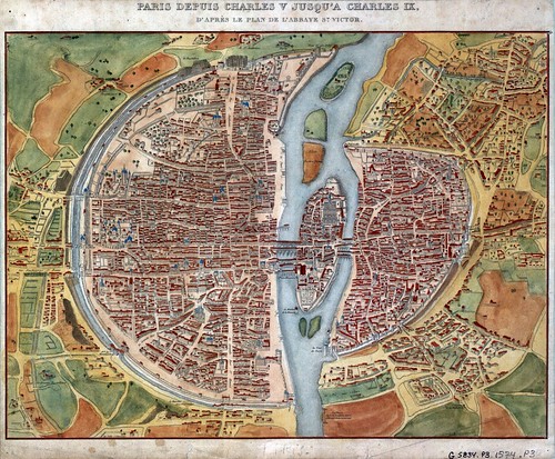
The title of this weeks featured map is:
Paris depuis Charles V jusqu’a Charles IX, d’après le plan de l’Abbaye St. Victor.
OR
Paris from Charles V to Charles IX, after the plan of the Abbey St. Victor.
That’s quite a long time period. In fact, the end of Charles V reign is dated at 1380 and the beginning of Charles the IX reign is dated at 1560. The additional information in the title referencing that it is after the plan of Abbey St. Victor gives us little help in narrowing down the dates of the map as the abbey was formed circa 1113. Also of note is that this map was published with the text “Tableau de Paris” By Louis-Sébastien Mercier in 1893. This is surely a later revised edition as Louis-Sébastien Mercier passed away in 1814.


To read an edition of this work look below to the embedded Google book. The edition is in French but if you copy the URL of the book and paste it in Google’s Translate tool you should be able to read it in English. (Tip: Set the text to “Plain Text” located in the upper right before translating)
Important features located on the map include Nostre Dame Cathedral now spelled Notre Dame:


La Bastille, an icon of royal power that was stormed at the beginning of the French Revolution:


St. Eustache Cathedral with a pipe organ numbering ~8000 individual pipes rivaling the pipe organ in Notre Dame. For photos of St. Eustaches stained glass windows click here.


And Porte Saint-Denis, a fortified gate in the walls of old Paris.


Also for fun, see how many windmills you can find on the map here’s an example:
