Yesterday, The Guardian’s DataBlog posted the above map of homicide rates, per 100,000 people, of countries around the world. The data is gathered from national sources by the United Nations Office on Drugs and Crime and can be found here. A handful of countries in South America and Africa show the highest rates while most of Europe, China, Australia, and Canada, among others, show the lowest rates. The United States falls in between.
Category Archives: Uncategorized
Connecticut Forum on Digital Initiatives – October 28, 2011 at Connecticut State Library
- Paul Baran, Assistant State Archivist, Connecticut State Archives
- Michael Bennett, Digital Projects Librarian & Institutional Repository Coordinator, University of Connecticut
- Jack Dougherty, Associate Professor of Educational Studies, Trinity University
- Chris Edwards, Digital Studio Production Manager, Beinecke Rare Books and Manuscripts Library
- John French, Director, Visual Resources Department, Yale Art Gallery
- Kathleen Foulke, Project Director, Connecticut History Online
- Michael Howser, Undergraduate Education and GIS Librarian, Homer Babbidge Library, University of Connecticut
- Gail Hurley, Statewide Library Catalog Coordinator, Connecticut State Library
- Brenda Miller, Curator, Hartford History Center
- Leah Prescott, Digital Projects Coordinator, Getty Research Institute
- Tom Scheinfeldt, Managing Director, Roy Rosenzweig Center for History and New Media
- Nick Stanhope, CEO, We Are What We Do/Historypin
- Kendall Wiggin, State Librarian, Connecticut State Library
A Sense of Place: Exploring Newport and Narragansett Bay Through Historic Maps Exhibit
For more information on the Redwood Library & Athenaeum map exhibition and symposium click here.
Envisioning the World: The First Printed Maps, 1472-1700 Exhibit
Time: Now through December 31, 2011
Cost: Free!
Reservations: The Naval War College Museum is open to the public and visitors must obtain a Visitor Pass to access the naval base and the Naval War College Museum. To obtain a visitors pass call (401) 841-4052 at least one day prior to your visit to obtain authorization to access the naval base to visit this museum.
Nationwide Protests Continue
 |
| This map, from Mother Jones, shows protests across the country. |
For over two weeks protesters have gathered on Wall Street in New York City. This movement, catalyzed by a sluggish economy, income inequality, and corporate greed has spread nationally and internationally. The protests have included mass arrests on the Brooklyn Bridge, questionable use of force by police, as well as people sharing personal stories of why they are upset. The map above, created by Mother Jones, uses Google Maps to show protests across the United States.
For more check out:
Twitter Hashtags – #ows #occupywallst
The Guardian’s Live Blog
We are the 99% Tumblr
The Times Atlas of the World Controversy
Last week I wrote a post regarding the publication of the Times Atlas of the World. Since then, controversy has erupted over the amount of ice loss conveyed in Greenland. Glaciologists and climatologist around the world are are disputing the publisher’s claim that 15% of Greenland’s permanent ice cover has been lost since 1999. One hypothesis for the error is a misinterpretation of a contour lines on a 1999 map. Click here for more.
History of Cartography Fellowship at U of Wisconsin-Madison
Complete information and application instructions are available at http://www.geography.wisc.edu/histcart/#fellow
GPS…One Billion Seconds Old!
On September 14, the atomic clocks that enable the Global Positioning System (GPS) struck 1,000,000,000 seconds. GPS was pioneered by the Department of Defense who set the beginning of GPS time on January 6, 1980. It wasn’t until the early 2000’s that GPS became widely available commercially. Before this, the DoD guarded this technology closely and did not allow the system to give civilians precise and accurate readings. This changed when, in 1996, then-President Bill Clinton signed an executive order to turn off Selective Availability (which became effective in 2000). GPS is now used for a wide variety of purposes including military, car navigation, recreation (see: Geocaching) as well as scientific research.
History Pin: Generations of Photos Mapped
History Pin is a web application that allows users to share and access historical photos. Much like MAGIC’s collaboration with On The Line, History Pin preserves history through digitization and links it with geography in an accessible, web-based format that uses Google products.
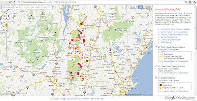
Yet Another Road Closure Map: Vermont
 |
| Google Maps serves as the base map while the VT Agency of Transportation provides the data for this map of road closures in Vermont. |


