Did You Know #22 What a Walkshed is?

Avencia Atlas has created a walkshed analysis tool for New York City and Philadelphia that I think everyone should check out if they get a chance. The creators label it an App but I think it’s a really elegant example of a map mash-up!

The way it seems to work is that the user (you) set weights to individual services on a sliding scale ranging from -5 to +5. These services include grocery stores, coffee shops, bars, Wifi hotspots, transit and more. See the image below.


The result is continuous raster layer with various scores indicating if it’s in a walkable location (the walkshed). Another nice feature of the output is that you can download the .kml file for viewing in Google Earth.

Avencia’s Decision Tree engine behind this neat map would allow for many different types of web based geographical analysis including sustainable development and environmental impact studies. Over all, Walkshed New York has an easy to use interface and polished aesthetic that is not seen in many mapping applications or map mash-ups! Special shout out to Brian Jacobs who designed the front end of this application. Go to his website at http://briantjacobs.com for more samples of his work.

Did You Know? #21 We’re On Facebook?

That’s right! There’s another way to follow blog! Outside the Neatline now has it’s own group page on Facebook! Anyone can join our group and we encourage you to contribute. We also have a Discussions Tab that will allow you to grill us on just about any geography related questions you may have. It’s also a great place to give your suggestions or share neat stuff you find on the web!

In addition to following us on Facebook, you can also follow our blog with an RSS and a feed reader (Google has a nice one, follow this link). Just look for this icon at the top of our page:


This video should clear things up a bit too:

Want to see what Jeff is reading using his Google Reader RSS Aggregator? OK! Follow this link!

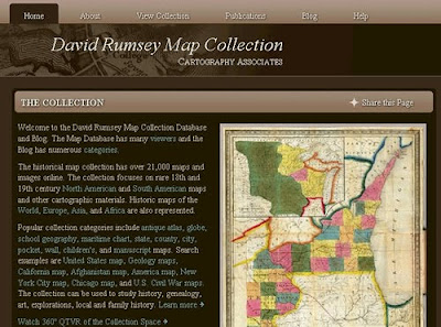
Did You Know #20 David Rumsey Map Collection

If you love exploring historical maps then be sure to check out the newly redesigned David Rumsey Map Collection website! This continuously growing online collection of maps includes the ability to:

  • Search the entire collection which includes maps from around the globe
  • View maps on Google Earth and Google Maps as georeferenced maps
  • Download images of maps in multiple sizes
  • Purchase print versions of maps
  • Embed maps into your website
  • And much more!

David Rumsey’s Map Collection is absolutely amazing and each map has been digitized with attention to detail that is almost unparalleled in the online map world. Take a few moments to explore this excellent online map collection, you will be glad you did!

Opportunities #3: Using GIS and Remote Sensing to Teach Geoscience in the 21stCentury

Applications are being accepted to participate in the “Using GIS and Remote Sensing to Teach Geoscience in the 21stCentury” workshop at Montana State University. This workshop will explore topics focused on enhancing the teaching of geoscience courses at the undergraduate level through the usage of GIS and remotely sensed data. This 4 day workshop is aimed at faculty teaching undergraduate courses and applicants must hold a faculty position at a two- or four-year college or university and have responsibility for teaching either GIS/remote sensing courses taken by geoscience students or geoscience courses at any level that have a significant GIS/remote sensing component.


The workshop will be held August 8-11, 2010 at Montana State University in Bozeman, Montana. Funding is available for part of the expenses, with the National Science Foundation contributing funding for this workshop. Additional details, including applications are available at: http://serc.carleton.edu/NAGTWorkshops/gis10/index.html

The deadline for applications is March 20, 2010.

Did You Know #19 Gowalla

If you have an iPhone and frequently use the social networking sites Twitter and Facebook then the Gowalla application is for you. This application enables users to share and locate restaurants, cafes, landmarks, parks, museums and other social environments. Users can add a location on a map using the iPhone’s GPS capability, add comments about the location and enables others to comment and share their experiences. If you use Twitter and have enabled geotagging you can share you location via Twitter from the App.

This is a truly social application and is Free for download from the iTunes store (at least free as of this posting on December 9, 2009) and is a great example of the crowdsourcing model for information creation.

This application is just one of many recently released iPhone Applications that utilize the location awareness capabilities of the iPhone (thanks to GPS) and social networking and blend them into one application.

This application was brought to our attention via our RSS feed from Tech Crunch.

Opportunities #2: CaGIS Scholarships

Applications for the 2010 Cartography and Geographic Information Society (CaGIS) scholarships are being accepted until January 15, 2010. Candidates must be enrolled full-time in a four-year undergraduate or graduate degree program during 2009 or 2010, studying cartography, geographic information science, or a closely related field. Awards range from $500 for masters degree seeking students to $1,000 for PhD degree seeking students.


For additional details visit: http://www.cartogis.org/awards/cagis-scholarships/scholarship

Did You Know #18 Natural Earth

We know it is crunch time for many GIS students out there as the semester is nearing the end so try Natural Earth for obtaining Free GIS Data (that’s right Free!) for areas beyond Connecticut. Natural Earth is an online GIS data warehouse which includes public domain map dataset at 1:10m, 1:50m, and 1:110m scales. Data appears to have both a United States and International focus with cultural, physical and raster datasets. The interface is intuitive and easy to navigate based upon our exploration of the site. Check out this site and let us know what you think!


Special thanks to Maps, Air Photo & GIS Forum Listserv for sharing this resource!

Opportunities #1: Newberry Library Fellowships

This is the first posting of a new series we are adding to Outside the Neatline to share opportunities for grants, fellowships, presentations, and publishing. The Newberry Library in Chicago, Illinois [map it] has a short term and a long term fellowship opportunity for to conduct research using their vast collections.

For short term fellowships, PhD and post-doctoral scholars are eligible and awards are typically for one month periods. Stipends are $1600 per month.

For long term fellowships, are designed to support research and writing by scholars with a doctorate for a range of 6-11 months. Stipends are up to $50,400.

Full details on the Newberry Library Fellowships are available at the following link.

Did You Know #17 Bing Maps Beta

Microsoft’ Bing Maps latest release is now officially in beta for users to try. This new version of Bing Maps using the Microsoft Silverlight platform and requires a user to install silverlight before they can use the new interface. Many users might be familiar with the Microsoft Silverlight platform as it is being used to provide access to streaming video content and other interactive media and is similar to Adobe’s flash media player.

Bing Maps Beta includes:
– Streetside View (Similar to Street View in Google Maps)
– Multiple Perspective Aerial Images (just as in the previous version)
– Streetside includes simulated 3D which in dense urban areas provides a realistic view of the area in 3D.
– Navigation controls are easier to find and rotating the image is extremely fast
– Bing Map Apps provide integration for Twitter and other data feeds

Below is a screen shot of Bing Maps Beta taken on December 3, 2009. As you can see the interface is more streamlined, includes weather data, and great color imagery.


For more details visit the Tech Crunch Blog for more details and reviews of Bing Maps Beta.