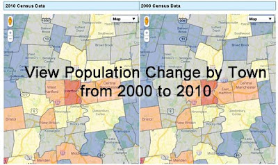
The Connecticut State Data Center has just released an interactive map to allow users to view 2000 and 2010 Census data for Connecticut towns. This map viewer allows users to search for a Connecticut Town, click on the town to view population, race/ethnicity, voting age, and housing data for 2010 on the map on the left and the user can view 2000 Census data for the town in the map on the right.
Category Archives: U.S. Census Bureau
Census Releases 2010 Data – Interactive County Map
<p>&amp;amp;lt;p&amp;amp;gt;IFRAMES not supported&amp;amp;lt;/p&amp;amp;gt;</p>
Census Bureau Ships Local 2010 Census Data to Connecticut
Today (Tuesday March 8, 2011), the Census Bureau shipped local 2010 Census data to the governor and leadership of the state legislature in Connecticut. After confirmation of receipt, usually within 24 hours of shipment, the Census Bureau will issue a news release with five custom tables of data for the state. Wednesday’s release is expected around 2 p.m. EST. At that time, the full set of data will be available via FTP download at http://www2.census.gov/census_2010/01-Redistricting_File–PL_94-171/. Within 24 hours after release, the data will be posted on the Census Bureau’s new American FactFinder site http://factfinder2.census.gov.
The data will include summaries of:
- Population totals
- Race
- Hispanic origin
- Voting age
Data will be available for multiple geographies within the state, such as census blocks, tracts, voting districts, cities, counties and school districts.
Census Bureau to Release Local 2010 Census Data for Connecticut
- Population totals
- Race
- Hispanic origin
- Voting age
This data will be released for multiple geographies within the state, such as census blocks, tracts, voting districts, cities, counties and school districts.
The U.S. Census on YouTube
Check out the following video highlighting the interactive Census data tools:
Census Bureau Reports the Number of Black-Owned Businesses Increased at Triple the National Rate
From The US Census Bureau Newsroom:
Census Bureau Reports the Number of Black-Owned Businesses Increased at Triple the National Rate
- Of the 1.9 million black-owned businesses in 2007, 106,824 had paid employees, an increase of 13.0 percent from 2002. These businesses employed 921,032 people, an increase of 22.2 percent; their payrolls totaled $23.9 billion, an increase of 36.3 percent. Receipts from black-owned employer businesses totaled $98.9 billion, an increase of 50.2 percent from 2002.
- In 2007, 1.8 million black-owned businesses had no paid employees, an increase of 64.5 percent from 2002. These nonemployer businesses’ receipts totaled $38.6 billion, an increase of 69.0 percent.
- The number of black-owned businesses with receipts of $1 million or more increased by 35.4 percent to 14,507 between 2002 and 2007.
2009 Annual Capital Expenditures Survey – US Census Bureau
From the US Census Bureau Newsroom:
2009 Annual Capital Expenditures Survey
2010 Census Data Released
The US Census Bureau Released 2010 Census Results for Louisiana, Mississippi, New Jersey and Virginia. Check out the neat interactive map they have provided with county level data! More states will be available as they are released.
<p>IFRAMES not supported</p>
Census To Release State Level Population Estimates
From the U.S. Census Bureau Newsroom:
State Population Estimates: April 1, 2010
Census Redistricting Data
Have Redistricting questions? Check out the U.S. Census Redistricting Portal:
http://www.census.gov/rdo/
Having problems generating GEOID’s from AFF check out the Tech Tips Here:
http://www.census.gov/rdo/tech_tips/
All you need to know about the 2010 Census Redistricting:
http://2010.census.gov/news/press-kits/redistricting.html

