Social Media, Hunting and Interactive Maps

Mapping social media is quickly becoming an everyday utility to understand our cultural landscapes (See Occupy Wall Street). But what about mapping natural phenomenon with social media?    I found the following map one of the most interesting intersections of social media, natural phenomenon and an outdoors pastime.  I found this interactive heat map on Field and Stream’s website.

The map requires a Facebook login and requires the users to report activity and rut phase of whitetail deer in the zip code that they hunt in.  The results are compiled and a heat map is generated on a daily basis.  Each one of the compiled maps is put in a time slider and allows the user to see changes over time.  
Of course the accuracy of the reports depends on the number of hunters who use Facebook, as well as those who are willing to submit their information.  I think it’s interesting nonetheless and worth checking out.

NPR and the Center for Public Integrity Investigate Poisoned Places of the U.S.

The interactive map from Poisoned Places: Toxic Air, Neglected Communities displays Toxic Inventory Release Information.

NPR and the Center for Public Integrity have teamed up for a special investigation series entitled Poisoned Places: Toxic Air, Neglected Communities. This series takes a hard look at the environmental protection, or like there of, in American communities. The series’ website includes an interactive map (see screenshot above) that displays the distribution of polluters all over the country. The map displays Toxic Release Inventory information, like the EPA’s myRight-to-Know application, but is much more user friendly than the EPA product.

More on this NPR series:

Part 1: Secret ‘Watch List’ Reveals Failure to Curb Toxic Air

Part 2: Oklahoma Town Battles Powdery Carbon Pollution

The Changing Landscape Of Cape Cod

Scientists at the Woods Hole Research Center “combine analysis of satellite images of the Earth with field studies to measure, model, and map the Earth’s ecosystems, from thawing permafrost in the arctic to the expanding agriculture regions of the tropics.” The WHRC studies regions all over Earth, including their own backyard. The second half of the 20th century brought significant changes to the home of the WHRC, Cape Cod, including a doubling in the population. This increase in population has transformed land use patterns, and consequently the landscape, dramatically. The images below depict land use: dark green represents forests, yellow represents residential areas, red represents commercial and industrial areas, light brown represents salt marshes, pale brown represents sand, while orange represents agricultural areas:

1951

1985

2005

The WHRC has made a variety of resources available regarding the Cape, including time series photographs of Falmouth, maps of land cover change by town, a description of critical habitats, and an exploration of why some areas on the Cape should be a priority for local governments to acquire.

Eyes on Political Violence in Syria

Yesterday, Syria accepted an Arab League plan to end the political crisis that has transpired over the last seven months. It is being reported that the proposal calls for the withdrawal of tanks and armored vehicles from cities, halting the violence against protesters, and for the Assad regime to open dialogue with the opposition within two weeks. There is some skepticism over the weight this proposal will carry, however, as Syrian security forces have opened fire on protesters in the past despite ceasefire orders, and reports are indicating that Syrian security forces have already violated this agreement by shelling residential areas of the city of Homs and killing four people.

Amnesty International has created an interactive map of the political violence in Syria, which can be seen below:

This screenshot from Amnesty International’s Eyes on Syria displays deaths occurring in custody of government security forces.

The map displays stories & photos and stories and videos for the following categories:

Documentation- Deaths in Custody, Harassment of Expatriates
International Solidarity – Activism Stories
Urgent Actions and Web Actions – Take Action

Join us for the Geography Awareness Week Kickoff Event – November 3, 2011 @ UConn

Are you interested in learning more about your local community through a geographic lens? Join us for today’s (November 3, 2011) event at the UConn Storrs Campus. Drop in registrations are welcome and UConn students are admitted for free! Details are included below.


Geography: The Adventures in Your Community
Thursday, November 3, 2011 4:45-8:00pm
Thomas J Dodd Research Center at UConn
Storrs, Connecticut
The heart of this year’s theme will revolve around a series of topics that encourage individuals or teams of students, families, or friends to explore their own communities through geographic eyes, and challenge them to look at things from a geographic perspective.
Program Agenda
4:00-4:30 Pre-conference tour of UConn Libraries – MAGIC
4:30-4:45 Registration – Thomas J. Dodd Research Center
4:45-5:00 Welcome – Bill DeGrazia & Tom Brodnitzki, CGA Co-Coordinators
5:00-6:00 Keynote Speaker – Arthur Bakis – U.S. Census Bureau Boston Regional Office
6:05-6:55 Buffet Dinner and Remarks
7:00-7:50 Breakout Sessions
I – Elementary Teachers – Allyson Lubs, Professional Development CGA
II – Middle & High School Teachers – Kristie Blanchard, NE Geography Teacher of the Year
III – Exploration of American Community Survey (ACS) –
Michael Howser, Connecticut State Data Center
7:50-8:00 CEU Records and Drawings

Participation Fee: $25 (add $10 if you would like to be awarded .3 CEUs upon completion of the program). The fee includes registration and a light dinner. Checks should be made payable to “Connecticut Geographic Alliance.
Pre-Service Teachers receive a reduced registration fee of $10 and currently enrolled UConn Students receive free admission.
This workshop is a collaboration of the Connecticut Geographic Alliance, University of Connecticut Department of Geography, University of Connecticut Libraries Map and Geographic Information Center (MAGIC), and the Connecticut State Data Center.
Participants can register at the door for this event.

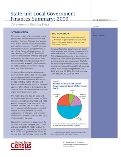
Census Bureau Reports State and Local Governments Revenue (Nationally) Declines 22 Percent in 2009

In 2009, state and local governments brought in nearly $2.1 trillion, a 22.1 percent ($587.5 billion) decrease from 2008, according to statistics from the U.S. Census Bureau. Most tax revenue categories saw declines except property tax, which saw a 3.7 percent increase to $424.0 billion.

These findings come from the 2009 Annual Surveys of State and Local Government Finances, which include statistics on revenues (including taxes), expenditures, debt and assets (cash and security holdings) for state and local governments.
Revenue from the federal government increased 12.3 percent from $478.0 billion to $536.8 billion between 2008 and 2009. (See Table 1 [Excel])
Spending increased 4.6 percent for state and local governments, totaling almost $3.0 trillion in 2009. Education continued to be the largest expense ($850.7 billion), followed by public welfare, which consisted of support of and assistance to needy people ($431.1 billion) and insurance trust ($275.5 billion). (See Table 1 [Excel])
Debt outstanding for state and local governments increased $131.1 billion (5.1 percent) to $2.7 trillion in 2009.
State and local spending on education comprised more than 33.0 percent of expenditures in nine states (Alabama, Arkansas, Georgia, Kansas, New Jersey, Texas, Vermont, Virginia and West Virginia). Elementary and secondary education totaled more than 24 percent of spending in New Jersey (25.8 percent) and Georgia (24.3 percent). Maine led the nation in state and local government spending on public welfare as a percentage of total spending (24.1 percent). (See Table 3 [Excel] and Table 4 [Excel])
For local governments, property tax revenue was up 3.7 percent to $411.0 billion. Public welfare spending increased 2.1 percent for local governments, led by vendor payments (payments to private vendors for medical care, hospital care, and other goods and services provided to needy people), which jumped 11.5 percent to $6.3 billion in 2009. Spending on utilities increased 6.4 percent, led by transit spending, which increased 13.8 percent. (See Table 2 [Excel])
Other highlights for state and local government finances:
  • Unemployment compensation saw an 86.0 percent increase from $35.6 billion in 2008 to $66.2 billion in 2009.
  • Insurance benefits and repayments increased 17.9 percent to $275.5 billion.
  • Spending on administering social insurance increased 12.6 percent from $4.1 billion in 2008 to $4.6 billion in 2009.
  • Revenue from individual income taxes decreased 11.3 percent from $304.9 billion to $270.5 billion.
  • Corporate income taxes revenue declined 19.2 percent to $46.0 billion.
  • Insurance trust revenue dropped 683.5 percent to $-498.0 billion, driven by employee retirement losses. Insurance trust revenue includes retirement and insurance contributions and earnings and losses on investment assets.
  • Cash and security holdings decreased 15.0 percent to $4.6 trillion because of a decrease in employee retirement assets, which declined 23.8 percent in 2009.
  • Spending on highways comprised more than 10.0 percent of expenditures in Alaska, North Dakota and South Dakota. (See Table 3 [Excel])
Data in this report are subject to sampling variability as well as nonsampling errors. Sources of nonsampling errors include errors of response, nonreporting and coverage. More details covering the design methodology are available online at <http://www2.census.gov/govs/estimate/2009_Local_Finance_Methodology.pdf>. All comparative statements in this report have undergone statistical testing, and unless otherwise noted, all comparisons are statistically significant at the 10 percent significance level.

Source: U.S. Census Bureau

A Survey of NYC’s Privately Owned Public Spaces

As of the morning November 3, 93 of the 391 privately owned public spaces had been visited.

WNYC’s Brian Leher Show and The New York World have initiated a mapping project to survey privately owned public spaces (like Zuccotti Park – home to Occupy Wall Street demonstrations) in New York City. The collaborators are asking the public to fill out a form that describes their experiences at the places. The questions include:

  • What day of the week did you visit the space?
  • What time did you visit the space?
  • Users are asked to rank the condition of the space (1-5)
  • What kinds of features define this space?
  • What kinds of activities are happening in this space?

The deadline for submissions is November 9th. The results of this project, which I look forward to seeing, should create an interesting narrative that describes what these spaces are like and how they are used, which is especially compelling in light of recent events.

Census Bureau to Release Supplemental Poverty Measure Research – November 7

On Monday, Nov. 7, the U.S. Census Bureau will release research on a supplemental poverty measure that complements, but does not replace, the nation’s official poverty measure.

Census Bureau subject matter experts will host a technical webinar Friday, Nov. 4 in advance of the release to provide background into the development of the supplemental measure as well as the methodology used.

The Census Bureau developed the supplemental poverty measure after years of research and collaboration with the National Academy of Sciences and other organizations. The supplemental measure is designed to reflect contemporary social and economic realities and further our understanding of economic conditions and trends.

Technical Webinar
What:                    The webinar will consist of a simultaneous audio conference and online presentation. Reporters will have the opportunity to ask questions after completion of the presentation. The webinar focuses on the technical issues surrounding the development of the measure; the research results will be presented and posted online Monday, Nov. 7 (see below).
When:                   Friday, Nov. 4, 10 a.m. EDT       
Who:                     Kathleen Short, research economist, U.S. Census Bureau
Thesia Garner, research economist, U.S. Bureau of Labor Statistics 
Details:                 Audio conference ― access information
                              Toll free number: 888-994-3819
                              Passcode: CENSUS
Online presentation ― access information
Please login early, as some setup is required.
URL: <https://www.mymeetings.com/nc/join/>
Conference/meeting number: PW9176213
Conference/meeting passcode: CENSUS
Note: Stay on the line until operator asks for the passcode. Do not key in passcode.
If closed captioning is required:
Seminar and Release of Supplemental Poverty Measure Research
What:             The Census Bureau will release a report on its supplemental poverty measure research results at a seminar co-sponsored with the Brookings Institution’s Center on Children and Families. Following the presentation on the findings, the Census Bureau’s subject matter expert will be available to answer questions from the media. The research report will be posted on the Census Bureau website at the conclusion of the presentation.
When:             Monday, Nov. 7, 2011
Presentation: 8:30 to 9 a.m. EST
Q&A session: 9 to 9:30 a.m. EST
Who:               Kathleen Short, research economist, U.S. Census Bureau
Where:           Brookings Institution
1775 Massachusetts Ave, NW
Washington, D.C. 20036
Presentation: Falk Auditorium
 Q&A session: Johnson Room (adjacent to auditorium)
Directions to Brookings can be found at <http://www.brookings.edu/about/directions.aspx>.
Contact:         Reporters planning to attend should contact D.J. Nordquist of Brookings at
                        <DJNordquist@brookings.edu>.

Connecticut Power Outages

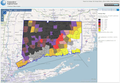
If, like me, you are still without power in Connecticut, you may find these following resources from Connecticut Light and Power useful:

Map of Affected Customers by Town – This map displays the percentage of CL&P customers affected by outages.

A screenshot of the CL&P outage map as of Tuesday, 2 PM.

List of Estimated Restoration Projects by Town – This list displays the estimated time that restoration projects will be completed. Some estimates indicate that electricity will not be restored until this weekend, while other towns are shown at all.

A screenshot of restoration estimates as of Tuesday, 2 PM.