Did You Know #16 Interactive Timelines

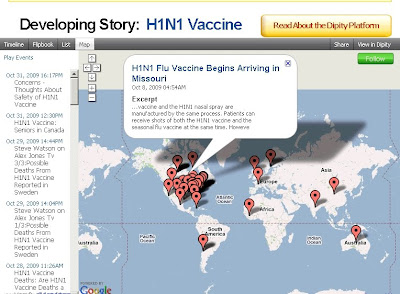
When developing research projects, a timeline of events can be extremely helpful for illustrating the sequence and inter-connectivity of concepts. Dipity is an online resource which enables you to create interactive timelines and includes a timeline, flipbook, list and map view. On the main page the site includes a top news story theme and provides an interactive timeline of events. Below are some examples of the Timeline and Map functions in Dipity related to the H1N1 Vaccine.


The dipity website also enables you to create a login where you can add content from Flickr, and RSS feed, blogs, YouTube, Twitter, and several other sources dynamically. You can even create individual events and add them to the timeline. Once you have created your timeline, post the link to Twitter, Facebook, Myspace, or embed the timeline widget on your own website!

Have fun experimenting with this site and share your feedback with us below.

Special Thanks to Steven Park from the University of Connecticut Learning Resource Center for sharing this link with us.

Did You Know? #15 GeoMentor Seeking Educators

Outside the Neatline (overseen by the University of Connecticut Libraries Map and Geographic Information Center) is seeking a GeoMentor relationship with formal(public/private schools) and informal educators(Boy Scouts, Girl Scouts, etc…) in the state of Connecticut. What exactly does a GeoMentor do?

“A GeoMentor ‘adopts’ a school, class, or club and supports the educator/s in working with youth. Using tools of geography (such as maps and globes, atlases, charts, imagery, and field work), the GeoMentor helps the educator and youth develop skills in geographic thinking.” ~ GeoMentor.org

Since Outside the Neatline is integrated with MAGIC we can offer access to one of the nations premier map collections, online geospatial data, knowledgeable mapping professionals. We are eager to create learning opportunities that provide interdisciplinary research and learning experiences.

Please watch the video below featuring the release of the GeoMentor program and visit the website to learn more about the program at http://geomentor.org

If you have any interest or questions concerning the program please contact Jeff Dunn at:

jeffrey.dunn@uconn.edu
or
magic@uconn.edu

Please use “Outside the Neatline” in the subject line for both addresses.

Did You Know? #8 Tracking Hurricane Bill

You can track Hurricane Bill and other hurricane activity in the Atlantic and Pacific Oceans at the National Weather ServicesNational Hurricane Center. You can also subscribe to a RSS feed that will automatically update you on changes in the storms status and provide you with GIS Shapefiles.

In 1938 A large hurricane made landfall in New England , visit the following resources for more information:

PBS
NOAA Coastal Services Interactive Map (GIS Data Download)
The University of Connecticut’s 1938 Hurricane Story
The Connecticut State Library 1938 Aerial Photos

Did You Know? #2

What is GIS an acronym for?

GIS can mean Geographic Information System or Geographic Information Science and both are correct. GIS is a powerful tool that enables geographers and other researchers to:

View
Store,
Manage
And analyze geographically referenced information (maps, imagery, and tables).

The individual components of a GIS that perform the above jobs are:

Computer Hardware,
Computer Software,
Data,
Methods,
And People.

GIS is an essential tool that allows the graduate students and staff at MAGIC to bring you maps, google mash-ups, and other geographic data.

Jeff and Brandon interpret aerial photography using GIS at MAGIC’s GeoCommons

For more information about GIS visit http://magic.lib.uconn.edu/ or http://www.gis.com/

The University of Connecticut also offers a certificate program in GIS

Introducing Outside the Neatline!

About Outside the Neatline:

Outside the Neatline is a collaborative effort of graduate students who work at The University of Connecticut Libraries’ Map and Geographic Information Center (MAGIC). Our aim is to give the public a better understanding of what we actually do all day besides high-fiving each other when we find a neat new map. What we actually hope to illuminate is the usefulness of historic maps, digitally storing and displaying paper maps, and how they may be used in current mapping technologies.

Things to look forward to from Outside the Neatline include:

  • Featured Map of the Week – The staff’s favorite picks.
  • How in the World? – How the graduate students turn paper maps into digital wonders.
  • Did You Know? – General geography facts, definitions, and other tasty tidbits.
  • And More! – We’re open to suggestions, what do you want to see?
The main objective of Outside the Neatline is to provide our audience geographical knowledge in a fun and lighthearted way. So we hope you enjoy your visits to our site and please feel free to make this an interactive experience!

About the Authors:


Jeff Dunn earned his M.A. in Geography at West Virginia University and is currently a PhD student of Geography at the University of Connecticut. During semester breaks he works at MAGIC as a GIS Analyst scanning maps, georeferencing, and developing geography curriculum. Jeff’s specific areas of interests are in remote sensing and coastal geography. Outside of academics, Jeff is an avid fly fisher.


Brandon Cramer is a PhD student in Geography at the University of Connecticut. He received his M.A. in Geography from the University of Connecticut in 2008. Brandon is mainly interested in using geography to examine environmental and health issues. He has worked with government agencies to reduce agricultural pollution and analyze geographic disparities in disease and illness. Over winter and summer breaks Brandon is a GIS Analyst at MAGIC and works on scanning and georeferencing current maps and creating custom maps to fit users’ needs by special request.