Public Education Finances: 2010

The nation’s elementary-secondary public school systems spent an average of $10,615 per pupil in fiscal year 2010, up 1.1 percent from the previous year, according to statistics released on June 21, 2012 by the U.S. Census Bureau. The state of Connecticut’s public schools spent $14,906 per student in 2010, placing Connecticut 7th in the nation in per student spending in 2010 with the District of Columbia public schools having the highest per student expenditure of $18,667 in 2010. A complete table with rankings by state is available from the U.S. Census Bureau (See table 11. Excel | PDF).

These updated statistics are included in the U.S. Census Bureau’s Public Education Finances: 2010 report, a report the provides data on revenues, expenditures, debt and assets of elementary and secondary public school systems from across the nation for the 2010 fiscal year. The tables include detailed statistics on spending — such as instruction, student transportation, salaries and employee benefits — at the national, state and school district levels.

Other highlights from this report include:

  • States that spent the least per pupil were Utah ($6,064), Idaho ($7,106), Arizona ($7,848) and Oklahoma ($7,896).
  • All nine states in the Northeast region of the U.S. were ranked among the top 15 in per pupil spending in 2010. Out of the 16 states with the lowest per pupil spending, 15 were in the South or West regions. The remaining state, South Dakota, is in the Midwest.
  • Of the 50 largest school systems by enrollment in the U.S., New York City School District ($19,597), Montgomery County Public Schools in Maryland ($15,582), Baltimore City Public Schools in Maryland ($14,711), Milwaukee Public School in Wisconsin ($14,038) and Prince George’s County Public Schools in Maryland ($14,019) had the highest per pupil spending in 2010.
  • Instructional expenditures accounted for the largest spending category for public education, totaling $317.8 billion in 2010, of which $211.1 billion (66.4 percent) went to instructional salaries and wages.
  • Public school systems in North Dakota (22.0 percent), Mississippi (21.2 percent), New Mexico (20.7 percent) and Idaho (20.4 percent) received the highest percentage of their revenues from the federal government, while public school systems in New Hampshire (6.6 percent), New York (6.7 percent) and the District of Columbia (6.7 percent) received the lowest.
  • Property taxes accounted for 64.8 percent of revenue from local sources for public school systems.
  • Total school system debt increased by 1.9 percent to $406.9 billion in 2010. 
View the complete report and download data in excel format at: http://www.census.gov/govs/school/


The data used in the tabulations came from a census of all 15,345 public school systems. As such, they are not subject to sampling error. Although quality assurance methods were applied to all phases of data collection and processing, the data are subject to nonsampling error, including errors of response and miscoding. For more information, visit the Census Bureau’s website at <http://www.census.gov/govs/school/>.

U.S. Employer Businesses Show Declines in Establishments and Employees in 2010, Census Bureau Reports

U.S. Employer Businesses Show Declines in Establishments and Employees in 2010, Census Bureau Reports

In 2010, U.S. businesses with paid employees numbered 7.4 million, a decline of 36,800 establishments from 2009, marking the third consecutive year of decline, according to the U.S. Census Bureau. In comparison, between 2008 and 2009 there was a decline of 168,000 establishments.


These findings are from County Business Patterns: 2010, which provides the only detailed annual information on the number of establishments, employees, and first-quarter and annual payroll for most of the 1,100 industries covered at the national, state and county levels. The statistics are broken down according to employment-size classes (for example, number of establishments with one to four employees) and legal form of organization (for example, corporations and partnerships).


In 2010, total employment from all sectors was 112.0 million, a decline of 2.5 million employees from 2009. In comparison, between 2008 and 2009 there was a decline of 6.4 million employees.


“This year’s release of the County Business Patterns shows the overall decline in employment is slowing,” said William G. Bostic Jr., associate director for economic programs at the Census Bureau. “In contrast, 2009 coincided with the height of the recession and showed higher declines in employment and establishments.”


Between 2009 and 2010, only Alaska showed a rise in employment from the previous year, having increased 0.7 percent. All other states showed declines in employment, led by Wyoming’s 4.5 percent decline from 2009.


Among the top 50 counties in the United States by number of establishments, the largest decline in total annual payroll was Los Angeles County, Calif., with a decrease of nearly $2 billion. This was a decrease of 1.1 percent from 2009. Only Kings County, N.Y., showed an increase in the number of employees with an additional 4,400 from the previous year.


The retail trade sector had the highest number of establishments (1.1 million). Next were professional, scientific and technical services (851,506); health care and social assistance (812,860); other services (except public administration) (725,488); construction (682,684); and accommodation and food services (643,960).


The construction sector showed the largest percentage decline in establishments, decreasing 4.2 percent from 2009 to 2010. The finance and insurance sector had the second largest decline, falling 3.2 percent from 2009 to 2010. The remaining top five sectors that showed the largest decline in establishments were manufacturing (2.9 percent), management of companies and enterprises (1.4 percent), and wholesale trade (1.2 percent).


Among industries that showed an increase in establishments, both utilities and health care and social assistance saw the largest increase, rising 1.7 percent from the previous year. The remaining top five industries that showed the largest increase in establishments were educational services (1.5 percent); accommodation and food services (1.4 percent); and professional, scientific, and technical services (1.1 percent).

County Business Patterns excludes business owners who were self-employed, employees of private households, railroad employees, agriculture production workers and most government employees. Information on businesses without paid employees is released as part of the upcoming 2010 Nonemployer Statistics report. County Business Patterns data by five-digit ZIP codes will be released this summer.

County Business Patterns 2010 – Connecticut Data


For Connecticut, users can view data at the state and county levels for 2010 from the County Business Patterns Homepage at: http://www.census.gov/econ/cbp/. From this page you will be able to access data on the total number of paid employees by NAICS code, view payroll information, identify the total number of establishments, and more. Included below is a brief table of the number of establishments in Connecticut by employment-size class based on the 2010 County Business Patterns dataset.


Number of establishments by employment-size class (2010) – Connecticut

NAICS code NAICS code description Total
establish-ments
1-4 5-9 10-19 20-49 50-99 100-249 250-499 500-999 1000
or more
—— Total for all sectors 89,234 47,372 17,338 11,932 7,835 2,591 1,638 332 110 86
11—- Agriculture, forestry, fishing and hunting 78 57 16 3 2 0 0 0 0 0
21—- Mining, quarrying, and oil and gas extraction 71 34 16 13 5 1 1 1 0 0
22—- Utilities 169 42 21 24 28 29 15 7 1 2
23—- Construction 8,187 5,904 1,129 660 358 82 47 6 1 0
31—- Manufacturing 4,473 1,669 825 713 669 317 201 48 23 8
42—- Wholesale trade 4,418 2,328 822 587 430 139 86 15 6 5
44—- Retail trade 12,940 6,075 3,011 1,899 1,259 343 323 29 1 0
48—- Transportation and warehousing 1,641 748 260 217 219 119 57 14 6 1
51—- Information 1,649 786 267 243 193 86 54 14 5 1
52—- Finance and insurance 6,339 3,336 1,487 849 364 153 83 32 18 17
53—- Real estate and rental and leasing 3,232 2,267 570 261 91 33 6 2 1 1
54—- Professional, scientific, and technical services 9,477 6,301 1,455 954 508 150 78 18 7 6
55—- Management of companies and enterprises 717 268 120 95 86 60 52 24 8 4
56—- Administrative and support and waste management
and remediation services
5,241 3,307 775 500 367 130 117 32 9 4
61—- Educational services 1,296 578 227 184 155 70 55 13 3 11
62—- Health care and social assistance 10,257 3,890 2,464 1,951 1,114 373 358 66 17 24
71—- Arts, entertainment, and recreation 1,607 840 244 216 184 91 25 6 1 0
72—- Accommodation and food services 8,004 3,176 1,512 1,528 1,379 345 59 2 1 2
81—- Other services (except public administration) 9,291 5,625 2,115 1,031 424 70 21 3 2 0
99—- Industries not classified 147 141 2 4 0 0 0 0 0 0


County Business Patterns defines employment as all full- and part-time employees who were on the payroll during the pay period that includes March 12. Data are obtained from Census Bureau reports and administrative records from other federal agencies. Quality assurance procedures are applied to all phases of collection, processing and tabulation to minimize errors. The data are subject to error from miscoding and estimation for missing or misreported data. Values associated with each establishment are slightly modified to protect the confidentiality of the location. Further information about methodology and data limitations is available at <http://www.census.gov/econ/cbp/methodology.htm>.

Source: U.S. Census Bureau & Connecticut State Data Center

Summary of State and Local Government Tax Revenue: 1st Quarter 2012

Summary of State and Local Government Tax Revenue: 1st Quarter 2012

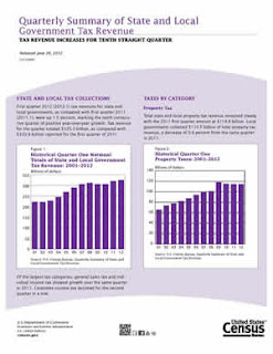
The U.S. Census Bureau’s Quarterly Summary of State and Local Government Tax Revenue provides quarterly estimates of state and local government tax revenue at a national level, as well as detailed tax revenue data for individual states. This quarterly survey has been conducted continuously since 1962. The information contained in this survey is the most current information available on a nationwide basis for government tax collections.

The 1st Quarter 2012 of the U.S. Census Bureau’s Summary of State and Local Government Tax Revenue has recently been released and indicates a total tax revenue of $3,604,124,000 for Connecticut during the 1st Quarter of 2012. Included below is the tax information for Connecticut from the U.S. Census Bureau’s Summary of State and Local Government Tax Revenue data for the 1st Quarter of 2012.

STATE TAX COLLECTIONS FOR CONNECTICUT AND TYPE OF TAX
1st Quarter 2012 (January , February, March)

Tax Description Code Connecticut
Total 
  $3,604,124,000
Property tax T01
X
General sales and gross receipts T09
$947,370,000
Motor fuel sales taxes T13
$115,191,000
Alcoholic beverages T10
$13,537,000
Public utilities T15
$55,786,000
Insurance T12
$88,478,000
Tobacco products T16
$91,950,000
Pari-mutuels T14
$1,719,000
Amusements T11
$100,079,000
Other selective sales and gross receipts T19
$134,698,000
Alcoholic beverages T20
$2,013,000
Public utilities T27
$176,000
Motor vehicles T24
$56,470,000
Motor vehicle operator T25
$10,587,000
Corporations in general T22
$7,606,000
Hunting and fishing licenses T23
$471,000
Amusements T21
$40,000
Occupation and business licenses T28
$30,963,000
Other licenses taxes T29
$2,314,000
Individual income taxes T40
$1,686,963,000
Corporation net income taxes T41
$212,989,000
Death and gift taxes T50
$18,649,000
Severance taxes T53
$15,000
Documentary and stock transfer taxes T51
$23,649,000
Other miscellaneous taxes T99
$2,411,000

View and Download Data
View additional states, the nation, and previous quarters of data from the U.S. Census Bureau at: http://www.census.gov/govs/qtax/

Nationwide Summary Report
View the National Summary Report for the 1st Quarter 2012 at: http://www2.census.gov/govs/qtax/2012/q1_infosheet.pdf

Older Populations to Exceed Children in Most World Regions by 2050, Census Bureau Reports

Older Populations to Exceed Children in Most World Regions by 2050, Census Bureau Reports

The world’s inhabitants in 2012 are an older mix of people than was the case a decade ago, driven by declining fertility and increasing life expectancy. According to new U.S. Census Bureau population projections, by midcentury most world regions will resemble Europe, which in 2005 became the first major world region where the population 65 and older outnumbered those younger than 15 (see Figure 1).

Figure 1: Europe Population Pyramid: 2005

Northern America, which includes Canada and the United States, will have joined Europe in this historic reversal of age group sizes by 2050 (see Figure 2), as will Asia (Figure 3), Latin America (see Figure 4) and Oceania (which includes Australia and New Zealand) (see Figure 5).

Figure 2: Northern America Population Pyramid 2050
Figure 3: Asia Population Pyramid 2050
Figure 4: Latin America and the Caribbean Population Pyramid 2050

Figure 5: Oceania (Includes Australia and New Zealand) Population Pyramid 2050
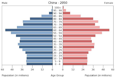
Moreover, China is projected to move from having nearly twice as many people in the younger age group than in the older one in 2012, to the opposite situation by midcentury (see Figure 6).
Figure 6: China Population Pyramid 2050

Each of these projections come from an update of the Census Bureau’s International Data Base, which includes estimates by age and sex to 100 years and older for countries and other areas with populations of 5,000 or more and provides information on population size and growth, mortality, fertility and net migration.

Since April 2012, users of the International Data Base have been able to obtain population in single years of age, allowing them to calculate country-specific populations in particular age groups (e.g., population at selected ages younger than 5, or adolescents).

Between now and the middle of the 21st century, global population will continue aging. The percentage of population 65 and older will more than double, from 8 percent today to nearly 17 percent in 2050, carrying with it well-established changes in the mix of communicable and noncommunicable disease patterns in populations, health care burden, pension systems, the composition and character of the labor force, and other economic variables, such as savings and consumption patterns.

One world region — Africa — will continue to have populations younger than 15 that are much larger than those 65 and older, but even there, the balance will have shifted toward the older group (see Figure 7).

Figure 7: Africa Population Pyramid 2050


View and Download Data
Want to explore additional population projections by country or region? View the data included in the charts above and more from the U.S. Census Bureau’s International Programs – International Data Base page at: http://www.census.gov/population/international/data/idb/informationGateway.php

This news release was provided by the U.S. Census Bureau with graphics added by the Connecticut State Data Center.

2010 Census of Population and Housing Units Counts – Connecticut

2010 Census of Population and Housing Unit Counts – Connecticut

The U.S. Census Bureau has just released a new report based on the 2010 Census for Population and Housing Unit Counts for Connecticut. This report includes housing units, population by urban and rural areas and more. Several of the tables also include historical census data at the state, county, county subdivision, place, and/or minor civil division levels for Connecticut.

This report provides easy to read tables of data which provides the same data available from the American FactFinder in a streamlined report. This report also includes population density, housing density and additional details which may be helpful to our readers.

Check out the full report at: http://www.census.gov/prod/cen2010/cph-2-8.pdf

U.S. Fastest Growing Cities between 2010 and 2011

The U.S. Census Bureau has just released a listing of the fastest growing cities between the 2010 Census (April 1, 2010) and the Population Estimates for July 2011. Based on the 2011 Population Estimates from the U.S. Census Bureau the largest percent increase in population from 2010 to 2011 was in New Orleans, Louisiana with a 4.9% increase. When we examine the total number of people rather than percentage, New York, New York added just over 69,777 people, the largest numeric increase in population in cities from 2010 to 2011. Check out the top 15 fastest growing, largest numeric increases, and largest populations cities in the U.S. based on the 2011 Population Estimates below:

Table 1. The 15 Fastest-Growing Large Cities from April 1, 2010, to July 1, 2011

Percent
Increase
2011 Total
Population
1.
New Orleans, LA
4.9 360,740
2.
Round Rock, TX
4.8 104,664
3.
Austin, TX
3.8 820,611
4.
Plano, TX
3.8 269,776
5.
McKinney, TX
3.8 136,067
6.
Frisco, TX
3.8 121,387
7.
Denton, TX
3.4 117,187
8.
Denver, CO
3.3 619,968
9.
Cary, NC
3.2 139,633
10.
Raleigh, NC
3.1 416,468
11.
Alexandria, VA
3.1 144,301
12.
Tampa, FL
3.1 346,037
13.
McAllen, TX
3.0 133,742
14.
Carrollton, TX
3.0 122,640
15.
Atlanta, GA
3.0 432,427

Table 2. The 15 Cities with the Largest Numeric Increase from April 1, 2010, to July 1, 2011

Numeric
Increase
2011 Total
Population
1.
New York, NY
69,777 8,244,910
2.
Houston, TX
45,716 2,145,146
3.
San Antonio, TX
32,152 1,359,758
4.
Austin, TX
30,221 820,611
5.
Los Angeles, CA
27,077 3,819,702
6.
Dallas, TX
25,413 1,223,229
7.
Phoenix, AZ
23,815 1,469,471
8.
Denver, CO
19,960 619,968
9.
Charlotte, NC
19,663 751,087
10.
San Diego, CA
18,773 1,326,179
11.
New Orleans, LA
16,911 360,740
12.
Fort Worth, TX
16,708 758,738
13.
El Paso, TX
16,416 665,568
14.
Washington
16,273 617,996
15.
San Jose, CA
14,875 967,487

Table 3. The 15 Most Populous Cities: July 1, 2011

2011 Total
Population
1.
New York, NY
8,244,910
2.
Los Angeles, CA
3,819,702
3.
Chicago, IL
2,707,120
4.
Houston, TX
2,145,146
5.
Philadelphia, PA
1,536,471
6.
Phoenix, AZ
1,469,471
7.
San Antonio, TX
1,359,758
8.
San Diego, CA
1,326,179
9.
Dallas, TX
1,223,229
10.
San Jose, CA
967,487
11.
Jacksonville, FL
827,908
12.
Indianapolis, IN
827,609
13.
Austin, TX
820,611
14.
San Francisco, CA
812,826
15.
Columbus, OH
797,434

Read additional details at: http://www.census.gov/newsroom/releases/archives/population/cb12-117.html

New Version of U.S. Census Bureau’s OnTheMap for Emergency Management Web Application

New Version of OnTheMap for Emergency Management Web Application

New features in the U.S. Census Bureau’s OnTheMap application improve access to workforce and demographic statistics for emergency preparedness, response and recovery activities. The application automatically incorporates real-time data updates from the National Weather Service’s National Hurricane Center, Department of Interior, Department of Agriculture, and the Federal Emergency Management Agency (FEMA).

New features include:

  • New emergency event data: Addition of FEMA disaster declaration areas and National Weather Service snowfall probability forecasts
  • More complete hurricane archives: Capture and archiving of all daily National Hurricane Center storm updates
  • Expanded report content: Addition of 2010 Census demographic and housing characteristics, and 2010 jobs and worker statistics
  • New analyses and visualizations: New reports with charting and thematic map overlays showing population and worker origin and destination distributions
  • New interoperability: New tool for exporting event areas to use in OnTheMap or other GIS applications
  • Updated interface and help documentation: Improved user interface speed and navigability, improved event searching, newly updated help documentation
View this new version of the OnTheMap for Emergency Management Web Application at: http://onthemap.ces.census.gov/em.html

A Half Century of Special District Growth Webinar


Webinar:
A Half Century of Special District Growth
Special district governments make up a significant portion of local government yet tend to be the most misunderstood type of government.  In the past 50 years, special districts have outpaced their county and municipal counterparts in growth in both number and significance.  This presentation will use Census data to explore the evolution of this type of government over time, attempt to explain how these governments are structured, how they operate, where they exist, what purposes they serve, and what the future might hold.

Date: July 24, 2012

Time: 2:00 PM – 3:00 PM Eastern 


PresenterSteve Owens, U.S. Census Bureau

Registration: 
 

“Free and clear” mortgage status data from the American Community Survey and 2010 Census

 Despite the expansion of mortgage debt in the last decade, according to the latest American Community Survey data one third of owner-occupied households (i.e. those owning – not renting or leasing – their house, condo, apartment, etc.) own their homes “free and clear” of any mortgage or home equity loan. In gathering this data, the Census Bureau’s American Community Survey questionnaire asks whether owner-occupied properties have a “mortgage, deed of trust, or similar debt,” and in the absence of any primary mortgage, whether there is a second mortgage or home equity loan (questions 19 and 20). Nationally, more than 24 million homes – 32.8% of owner-occupied housing units – have no primary or secondary mortgages. The prevalence of free and clear mortgage status for owner-occupied housing units varies regionally from 23.5% in Maryland, to 50.3% in West Virginia:

&amp;amp;amp;lt;a href=”undefined”&amp;amp;amp;gt;&amp;amp;amp;lt;img alt=”Dashboard 1 ” src=”http:&amp;amp;amp;amp;#47;&amp;amp;amp;amp;#47;public.tableausoftware.com&amp;amp;amp;amp;#47;static&amp;amp;amp;amp;#47;images&amp;amp;amp;amp;#47;Mo&amp;amp;amp;amp;#47;MortgageStatusAgeandIncome&amp;amp;amp;amp;#47;Dashboard1&amp;amp;amp;amp;#47;1_rss.png” style=”border: none” /&amp;amp;amp;gt;&amp;amp;amp;lt;/a&amp;amp;amp;gt;

 Connecticut lags slightly behind the national average in the percentage of owner-occupied housing units owned free and clear in the state; according to American Community Survey 2010 data, 28.5% of owner-occupied homes in Connecticut have no mortgage debt. Of these households, trends in the age of the householders, and median household income, were consistent with national trends. About 60% of the householders (the individual completing the ACS questionnaire) in mortgage-free households were 65 or older; 39% were aged 35-64, and only 1.4% were under 35. In Connecticut, as in all states, median household income in owner-occupied homes is significantly less than in households where the home is mortgaged. Median household income in Connecticut among households carrying a mortgage was $94,298, while median income in mortgage-free households was $52,435.

 Homeownership and mortgage status data were also gathered by the 2010 Census. Question 3 of the 2010 Census questionnaire asked if the housing unit was either “owned by you or someone in this household with a mortgage or loan? Include home equity loans”, or “owned by you or someone in this household free and clear (without a mortgage or loan)”. For mortgage status information at the town level, the Census 2010 data provides more current data than the ACS 5-year Estimates. According to 2010 Census figures, 26.4% of owner-occupied homes in Connecticut were owned free and clear (slightly less than the figures published for the 2010 ACS 2010 1-year estimate). Free and clear status among owner-occupied homes among Connecticut towns ranged from 16.2% in Sterling, to 41.2% in Cornwall.

&amp;lt;a href=”undefined”&amp;gt;&amp;lt;img alt=”Dashboard 1 ” src=”http:&amp;amp;#47;&amp;amp;#47;public.tableausoftware.com&amp;amp;#47;static&amp;amp;#47;images&amp;amp;#47;of&amp;amp;#47;ofCThomesownedfreeandclear&amp;amp;#47;Dashboard1&amp;amp;#47;1_rss.png” style=”border: none” /&amp;gt;&amp;lt;/a&amp;gt;

For detailed data from the American Community Survey in American FactFinder, see:

For additional data on mortgage status from the 2010 Census in American FactFinder, see:

On The Map for Emergency Management Webinar – June 20, 2012

Webinar:
OnTheMap for Emergency Management
June 20, 2012
1:30 PM – 2:30 PM Eastern

Discover OnTheMap for Emergency Management Version 3 new features that improves access to and utility of Census workforce and demographic data for emergency preparedness, response, and recovery activities including incorporating Federal Disaster Areas, Snowfall Forecasts, and 2010 Census demographic and housing characteristics.
Presenter:
Robert Pitts, U.S. Census Bureau
 
For registration questions, please contact Lauren Gilchrist.  For content-related questions, please contact Earlene Dowell.